|
Mobile Eminences |
| 2020-12-28 |
Mobile Eminences

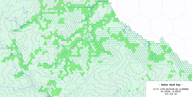
Hundred meters wide hexagons with elevation, wood cover, rivers, ponds and lakes. This is starting to get nice.
There are still some twists with the rivers, they run uphills in a few cases, I should find a way to mark such places, it can be explained by a ravine.
The woods as feared of are 2020ish, it should be okay, but I need to investigate Northumbrian forest cover, maybe the Royal Navy turned a fair share of it into ships of the line.
You can browse the sample map, dropping the pointer and moving around is fine, hitting '?' to show the help panel can help too.
I'm not satisfied with the way elevation deltas are shown, but I'll work again on that at a later stage. The lakes are blue circles for now, maybe I'll go and fill full hexes lake-blue, but there's already a spot with a lake spanning two elevations levels, doh.
It's usable on an iPad, it prints okay. For now, the menu gets in the way on an iPhone, but in portrait mode, it's still usable.
I can start using it for my scenario preparation. I may try to use it with players too to show them approaches and landscapes.
The OpenStreetMap dataset has historical places, especially tumuluses, that can prove good fun.
I wish there was a way for me to determine which of the roads to draw. Maybe I can ignore motorways and show national roads, betting on them being cowpaths that got paved. I could probably show footpaths as well. Maybe I can query for roman roads.
I also need to try and generate maps for european sites with more hills.
One can append a URL fragment to the map address to set the start point and initial zoom, as in https://weaver.skepti.ch/docs/20201228_mobemin.html#50,50/3000 (place NW corner on hex 50,50, show 3km of width).


